Plans of British Army Facilities in Dublin
The Military Archives of the Irish Defence Forces has an extensive online collection of plans and drawings of former British military facilities in what became the Irish Free State, later the Republic of Ireland. Upon independence in 1922 the Irish Free State took title to all British War Office property in the 26 counties of the new nation and received the architectural drawings and schematics for such property from the Royal Engineers. The Military Archives is the custodian of such documents on behalf of the state.
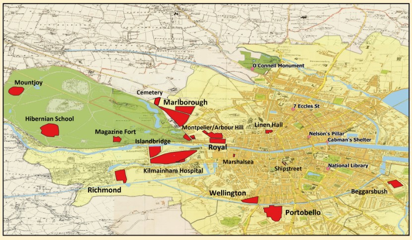
Dublin, 1904
Army Facilities and Places in Ulysses
From the Frequently Asked Questions, www.militaryarchives.ie/en/faq:
Who owns the copyright for content on this website?
"Military Archives is the official place of deposit for government records on Defence and the Defence Forces under the terms of the National Archives Act, 1986. The records held in Military Archives are therefore protected under Copyright law.
Due reference must be given where sources from Military Archives are used in the production of a publication, blog, website or any analog or electronic medium whatsoever. If any material held in Military Archives is to be used in a publication of any kind, in particular images from this website, from online collections or from digital photography taken in Military Archives reading room or at a Military Archives exhibition, written permission must be sought in advance from the Officer in Charge, Military Archives."
Note that ownership of both the digital images on the website and the underlying documents is claimed by the Republic of Ireland. Accordingly, non-personal use of the material in any form requires the permission of the state through the Officer-in-Charge, Military Archives. Additionally, if such permission is obtained proper attribution must be given to the utilized material.
To access the digitized maps, plans, and drawings of the Military Archives click on the link below. In response, a new browser window will open on your computer screen. Accept the terms and conditions to proceed to the collection.
Selected Plans from the Irish Military Archives
Click on a link below and the image for the plan will open in a pop-up window. To open the high-resolution image in a pdf, first click on View in New Window. After the new window opens, click on the image. Finally, click on the download icon near the upper-right window corner.
Home to the 14th Engineer (Survey) Company. Currently located here is the Ordnance Survey Ireland.
Munition stores for the Dublin garrison.
Purpose-built cavalry barracks and the last British Army facility built in Dublin. Currently used by the Irish Defence Forces (McKee Barracks).
Army isolation hospital, depot for militia medical company, and ordnance stores.
Quarters for several support companies and an infantry battalion. Oldest barracks in Ireland and the first barracks built in Europe. Now houses the National Museum of History and Decorative Arts.
HQ of Dublin Recruiting District and recruit reception center. Space for an infantry battalion but not occupied in 1904. Destroyed by fire during the Easter Rising of 1916.
Infantry barracks for one battalion.
Housed ASC Company B (Remount) and 15th Ordnance Company.
Nursing home for disabled and destitute army pensioners.
Small facility not in use in 1904.
Large infantry barracks that could accommodate two battalions. Home to Privates Carr and Compton. Currently in use by the Irish Defence Forces (Cathal Brugha Barracks).
Depot for militia and imperial yeomanry units.
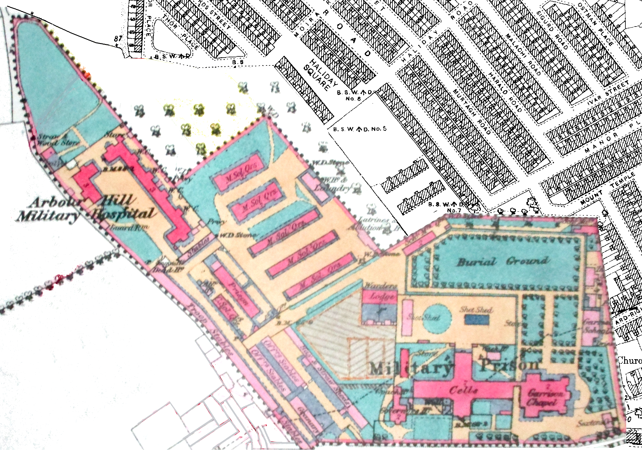
Army general hospital (100 beds), quarters for the 14th Medical Company, militia medical company depot, prison, garrison chapel, married soldiers' quarters, and Army Service Corps barracks. The general hospital is currently in use by the Irish Defence Forces (St. Bricin's Military Hospital). Click on the image to the right for a larger view of the 25-Inch Map of the area. It will open in a popup window.
Dublin Army Facility Plans on Major Tweedy's Neighborhood
Click on a link below and the image, in a pdf, will appear in a pop-up window.
Military boarding school for sons of Irish soldiers. Rendering of the Ground Floor based on the War Office plan of 1905 and the Ordninance Survey of Ireland 25-Inch Map, 2nd Revision. RHMSPlan.pdf (940 KB).
Built in the late 18th Century as a hospital for the Dublin Garrison, by 1904 it had military patients from all Ireland. War Office Plan, 1884. UK National Archives WO 78/4743/9. MilitaryInfirmary.pdf (804 KB).
Large infantry barracks that could accommodate two battalions. War Office Atlas Plan, 1879. UK National Archives, WO 78/3124. RichmondBarracks.pdf (4.3 MB).
Irish Command Headquarters
Office buildings located on the grounds of Royal Kilmainham Hospital.
Quarters for support troops and offices for the Dublin Garrison (13th Brigade) HQ. Located on the grounds of Dublin Castle. War Office Ground Plan, 1908. UK National Archives, WO 78/3053. ShipStreetBarracks.pdf (4.4 MB).
Opened in 1876; last burial in 1999. Ordance Survey of Ireland, 25-Inch Map. GrangegormanCemetery.pdf (2.0 MB).
Leased facilities at 23-25 Great Brunswick Street. War Office Record Drawings, 1905. UK National Archives, WO 78/3630. BrunswickStreet.pdf (858 KB).
[ You are at www.majortweedy.com>British Army>Plans of Facilities in Dublin ]